Conceptual Design
Interested?
Here, you find general information to conceptualize your own scenarios as well as an example to test the approach.
Didactical basis for this project are diverse tasks and questions concerned with recording or visualising spatial data during excursions or within the framework of lectures. The objective is to convey a better understanding of the spatial aspect of these tasks to the students. You can find ideas and inspirations under Showcases.
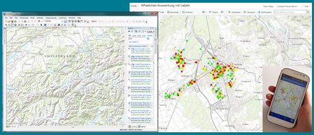
Technical basis for the field experiments with mobile data collection are standard products of the company external page Esri (external page ArcGIS for Desktop, external page ArcGIS Online, external page Collector for ArcGIS App).
A GPS-equipped smartphone or tablet as well as the free-of-charge Collector for ArcGIS app (iOS, Android & Windows Phone) are necessary for conducting the experiment, i.e. mapping.

In order to implement your own experiment GIS-knowledge and the necessary software licences are required. The students do not require prior GIS-knowledge to collect spatial information with the Collector for ArcGIS app.
To test the app we provide an example on our homepage. If you are interested in the technical specifications (data model, publishing on ArcGIS Online) you can find the according description under instructions. In this case you need ArcGIS Desktop as well as an ArcGIS Online licence.
Information for lecturers of ETH Zurich:
- If you are interested, however, do not possess GIS-knowledge or if you have didactical questions, please contact the .
- If you have GIS-knowledge but do not yet have access to ArcGIS Online, please also contact the .