Neophytes and Neozoa
Neophytes and neozoa are alien, that is, non indigenous plants and animals which have established themselves in nature and can, therefore, spread. Amongst them are the tree-of-heaven, the giant cow parsnip, Impatiens glandulifera, or the external page Asian tiger mosquito (Aedes albopictus). The Swiss flora encompasses around 3200 species, including 500 to 600 neophytes. 58 species are considered to be invasive or potentially invasive neophytes (see external page info flora).
The two field experiments "tiger mosquito" and "Akabia quinata" are designed to give the students an understanding of the extent of neophyte and neozoa propagation. In particular, the importance, dangers and reconnaissance of neophytes and neozoa as well as measures to monitor and control invasive species are discussed.
Tasks
Within the framework of two mapping tasks the students should:
- record potential breeding grounds of tiger mosquitoes in the communities Sementina (2014), respectively, Arbedo-Castione and Bellinzona (2015) in Ticino. The following questions should then be investigated: Where are potential breeding grounds of tiger mosquitoes in the communities? Which type of breeding grounds are dominating? Is a spatial pattern recogniseable? How can the tiger mosquito be controlled and which measures are necessary for this? Can consequences of performed preventions of certain communities be recognized in the recorded data?
- map the natural, vegetative spread of external page Akebia quinata (chocolate vine) of a local invasive East Asian type of vine close to Tegna (Ticino). The objective of this task is to visualize the extent of Akebia quinata's competition to indigenous plant species. This, in turn, should serve as a discussion basis for the dangers and damages that neophytes pose on environment and humans. Sampling over several years adds a temporal component which allows assumptions of vegetative propagation over longer time-spans.
Two field experiments were prepared for the implementation.
Field Experiment "Tiger Mosquito"
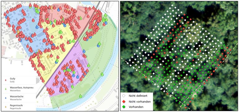
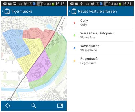
The recording of potential tiger mosquito breeding places was carried out by inspection of the community. With the help of the Collector for ArcGIS app the following four types of potential breeding grounds were mapped: (1) drains, (2) water barrels, car tyres, (3) puddles of water and (4) rain gutters.
For this experiment no further material was needed.
In 2015, the same method was used to map areas with prevention (northern Bellinzona) and without prevention (center of Arbedo). In advance, the students got assigned routes which were made visible in the app.
Field Experiment "Akebia quinata"
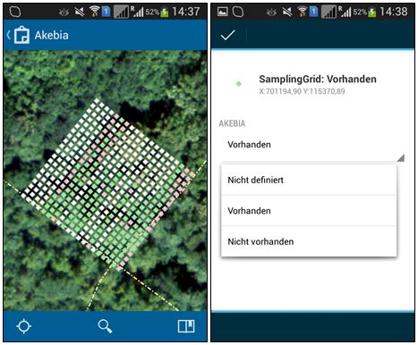
To map Akebia quinata, 20 x 20 sample points were calculated with a distance of 2 m between points and displayed in the Collector for ArcGIS app. The default value of "not defined" was assigned to all sample points. Mapping was done with the Collector for ArcGIS app. As opposed to the "tiger mosquito" field experiment, however, no new features were created, but the properties of the sample points were adapted. The students could choose between "present" and "not present".
Crowd-Sampling Phase
In 2014, 31 students took part in the excursion. They were divided into groups of two (with one group of three). Both mappings were done in real-time so that the students were able to see their own recorded breeding grounds, respectively, the adapted sample points as well as those of the other groups, immediately.
For the mapping of the tiger mosquito the area around the motorway services "Bellinzona-South" was seperated into five zones in 2014. Three to four groups were then assigned to each zone. When a potential breeding ground was found, the type could be chosen via "map new feature". The localisation was done automatically with the integrated GPS of the mobile devices. A manuel correction could be achieved with the help of the background map. During the available 30 minutes around 400 objects were recorded. The proportion of drains was dominating with an amount of 305 objects.
In 2015, sampling took place in groups of two along pre-defined routes and starting from two different points. Within 30 minutes, 570 objects were recorded like this. 92 of these objects were open containers, their removal being the target of prevention measures.
To record the occurrence of Akebia quinata (only 2014) each group had to edit a row of 20 sample points. During a time-span of 10 minutes, 190 quadrants could be investigated. In 133 of these plots an offshoot of the plant was found.


Discussion
Recording the different potential breeding grounds of tiger mosquitoes demonstrated two aspects vividly on both excursion: 1) road gullies are numerous, nevertheless, prevention can be organized by the community. 2) Prevention of open vessels lies in the responsibility of the population and is carried out with varying success. With the chosen method, potential breeding grounds on private property cannot be recorded completely. Therefore, the assumption is that the frequency of potential breeding grounds corresponds to the frequency of the recorded area.
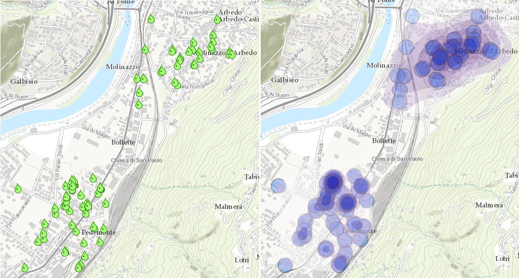
The spreading distance of adult and, therefore, potentially egg-laying tiger mosquitoes is a maximum of around 100 m. It would, thus, be possible to greatly reduce spreading of the mosquito with a sufficient distance between potential breeding grounds. Assuming that communities treat rain gullies, the distances between existing water vessels give information on the potential of unstopped propagation over several generations (generation time 7-14 days). During these first two excursions, this was directly achieved with the recorded data points. In the future, graphical analysis of ArcGIS Online will be used directly after data collection and added to the map (see figure above on the right).
During data collection the students came into contact with the local population and received direct information on how seriously the preventions are undertaken and which interventions have already been implemented without public prevention measures. The excursion 2015 revealed that there is a similar amount of breeding grounds in communities with and without prevention and that hotspots exist in certain quarters. In these districts, improvements might be achieved with increased information through authorities.
In this field experiment the students also have to deal with legal and organisational questions. Can a backyard be entered? How big are the areas which could not be mapped? Are the assumptions reasonable?
The mapping of Akebia quinata was only carried out in 2014 and left out in 2015 due to time constraints. For 2016 mapping of Akebia quinata in the same location is intended in order to document the spread or retreat of the species. In the mapping of 2014, however, it was discovered that the propagation already stops in the vicinity of small trails.
Feedback
The feedback on the excursion as well as the two field experiments was mainly positive as the following comments reveal:
- "I found recording the possible breeding grounds with the app very innovative."
- "...Also the mapping exercises were a good idea."
- "It was incredible to see how many plants do not originally come from Switzerland. In addition, it was interesting to try out this app for mapping."
- "Very well done and interesting explanations on the topic, mapping was great, beautiful hike."
- "I saw the difficulties in collecting a suitable amount of data and learned methods (e.g. Esri-app) to solve this problem. In addition, I walked through nature more aware in the end."
Next to these positive remarks there was one very negative feedback: "...additionally, I don't find the work with smartphones/tablets suitable for an excursion. First of all, one cannot (yet) assume that everyone owns such a device. Secondly, it is very difficult to get all devices to function as they should. ...In addition, work with the smartphone/tablet is tiring and boring. ..."
Lessons Learned
Discuss measures based on collected data. After the analysis (are there propagation corridors, how much effort does the treatment of gullies require) specific measures to prevent spreading can be derived from the data and discussed with the responsible persons. For this purpose, the illustration of results should be as meaningful as possible.
Make more use of analysis tools of ArcGIS online. The immediate informative value of the collected data can be magnified with suitable analysis methods for the discussion. The analysis can be done with ArcGIS Online.
Sensitize students on the contact with population. During data collection the students frequently came into contact with the population and received details of the prevention measures or were able make residents aware of these. These aspects could be increased if the students actively asked the population if they can also inspect the inaccessible areas.
Limitations of GPS reception. When data was collected in the forest the GPS-measurements were sometimes too inacurate to be useful. In this case, the position had to be determined through visible reference points in the terrain.


