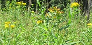
Mapping the Narrowleafed Goldenrod
With the renaturation of the Thur between Eggrank and the estuary of the Thur the biggest floodplain area of the Swiss Plateau was created. In the course of the measures a multitude of different habitats was created within a confined area (external page Naturzentrum Thurauen, external page Office of Landscape, Agriculture and Environment, canton Zürich). However, alongside these habitats, neophytes such as external page Solidago graminifolia about which yet little is known, can be found. Momentarily, the propagation potential of Solidago graminifolia is still considered as unproblematic for the floodplain area. However, it would be of great interest to know more about the location and the coverage of the species in the Thur floodplain.
Task
Within the framework of a Bachelor thesis the locations of Solidago graminifolia were mapped for a first time in July / August 2014 in the Thur floodplane.
Mapping was carried out by Andrea Weber at the Department of Environmental Systems Scienceof ETH Zurich in the framework of a Bachelor thesis (2014/2015) in collaboration with external page Naturzentrum Thurauen and Andrea De Micheli, coordinator for neophyte control in the Thur floodplains.
Mapping
In order to map the known locations two GIS datasets were modelled in ArcGIS for Desktop and made available in the Collector for ArcGIS app via ArcGIS Online.
The first dataset contained a regular polygon grid of 10 x 10 m. This rather coarse sampling grid size was deemed necessary, because GPS accuracy was at around 3 m. With the 10 x 10 m grid it could be garanteed that mapping took place within the delineated quadrants. The second dataset is a point dataset and represents the central point of every 10 x 10 m square.
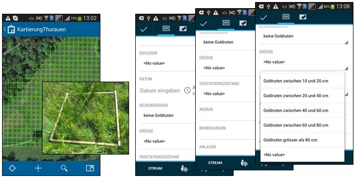
Every raster area could be assigned the property "no goldenrods", "few goldenrods" or "many goldenrods". Beyond that the following additional parameters can be recorded: date, cover ratio, size of the plants and state of vegetation. In addition, there is the possibility to add a comment as well as attachments such as photos or documents to the dataset. The named properties were not defined for the entire area of a raster but representatively within a 1 x 1 m frame within an area.
For mapping the new discoveries a point dataset with the following attributes was created: number, density, areas, remarks. The location of the new discoveries was recorded with the help of the GPS and a high-resolution aerial image.
Results
The two following images show the results of the field mapping. The first image shows an overview of the mapping results underlaid with a digital elevation model (resolution: 0.5 m) and overlaid with a dataset that shows the "sparse forests".

The high resolution terrain model clearly reveals the former course of the Thur river. The known occurrences of Solidago graminifolia are located in the area of the former riverbed. In this area the groundwater runs very close to the surface. Therefore, these locations are rather humid, which of advantage for Solidago graminifolia.
In addition, the image shows that some new discoveries were made in the area of the floodplains. Conspicuous is that the new discoveries are often located close to or within sparse forests.
The second image shows the size and the state of vegetation at the time of recording of Solidago graminifolia of two known sites.
The first area reveals mostly smaller, not flowering plants. This can be explained by the fact that this area has been already mowed once in spring. In the second areas bigger flowering plants were found. These plants will be removed here.

The Bachelor thesis showed that Solidago graminifolia has a certain invasive potential which has not reached its apex yet. Since mapping in the floodplains of the Thur was conducted only once, no conclusion can yet be drawn concerning the species invasiveness. However, it is recommendable to observe and map the sites regularly and, if possible, control the plant's propagation by removal.