Mapping Urban Gardening Sites

"Urban horticulture is the study of the relationship between plants and the urban environment. It focuses on the functional use of horticulture so as to maintain and improve the surrounding urban area." (see external page Wikipedia). Urban gardening has gained momentum in recent years.
Mapping Sites of Urban Horticulture
With this example you can map urban horticulture locations globally. For mapping a dataset with the following attributes, and partially pre-defined properties, is at your disposal:
You can find the complete data model here: Download data model "urban horticulture" (PDF, 76 KB)
Instructions: Collector for ArcGIS App

To participate you need to install the external page Collector for ArcGIS app (iOS, Android & Windows Phone) on your mobile device.
1. Internet Connection & GPS
Connect to the internet with your device and switch on the GPS function. open the app and insert the following link:
https://egregis.maps.arcgis.com (User: GISsmoxPublic, PW: GISsmoxP1).
You can find the further procedure in the following descriptions. The screenshots originate from an Android interface.
2. ONLINE Data Recording
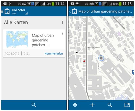
In the display under All Maps the map "Map of urban gardening patches - Karte mit urbanen Gartenanbauflächen" appears.
Click on this map. The map image opens. Please do not click on "download" (Herunterladen).
If you have switched on your GPS function your current location is shown.

3. Recording Objects
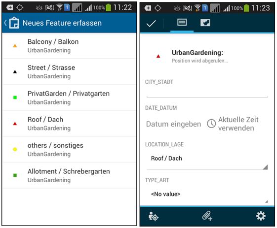
Record a new urban horticulture site with +. Automatically, the window Collect a new feature opens.
Choose the appropriate location from the pre-defined properties. The bilingual (German and English) labels are an exeption for this example.
A futher window opens in which you can specify further parameters:

- City_Stadt: Insert the name of the city, here, in which you have collected the data;
- Date_Datum: Click on "Use current time"; the date will automatically be set;
- Location_Lage: The according settings have already been chosen, however, can be changed once more at this point;
- Type_Art: Click on this field. Here you can also choose from pre-defined attributes;
- Size_Groesse: Estimate the size of the horticulture area and choose the according category.
Additionally, you have the possibility of adding an attachment, e.g. a picture of your location.
If your GPS - and, therefore, the location of the horticulture area - is not accurate enough, you can click on the map symbol in your menu and move the point by tapping on it.
With the checkmark in the toolbar you can conclude your entry. During online data collection it will automatically be saved and synchronized via the internet.
Alternative: OFFLINE-Data collection
If you should not have access to the internet during data collection click on Download under All Maps (see point 2).
Choose a map extent in which you would like to record data. This extent should, however, not be bigger than 5 MB. Click on Kartendetail Auswählen and then on Download. The map is now available offline. Mapping is then carried out as described under points 2 to 4.
To write the collected data back into the dataset connect to the internet after completing data collection and click on synchronise in the map overview. Your recorded data will now be synchronised via the internet and, therefore, be visible for everyone.
Web-Browser
This map is available to all interested persons. If you would simply like to take a look where urban horticulture has already been mapped you can click on the following link: external page Map of urban gardening patches - Karte mit urbanen Gartenanbauflächen.