Urban Gardening
For this example, the following information and tutorials are at your disposal:
1. Data Modelling
For the example "urban gardening" is is sufficient to generate a point dataset which contains the desireable information. There are:
- the city, in which the horticulture area has been sighted,
- the date, as well as,
- the position, the type and the size of the urban horticulture area.
In addition, it should be possible to attach an image of the respective site. As background information the topographic map (Basemap of ArcGIS Online) is available for better orientation.
You can find the conceptual data model here: Download data model "urban gardening (PDF, 76 KB).
In a next step, this conceptual data model is implemented in the Catalog Window of ArcMap. As data format an Esri File Geodatabase is chosen. The point dataset is a Feature Class containing the according attributes. Since this is a globally applicable example the projected reference system WGS1984 Web Mercator (auxiliary sphere) was chosen.The pre-defined properties are specified as domains and assigned the respective attribute. You can find a detailed description of the procedure here:
Download Instruction:data modelling"urban gardening" in ArcGIS for Desktop (PDF, 191 KB)
2. Data processing in ArcMap
At first the created Feature Class Urban Gardening is loaded in ArcMap and tested.
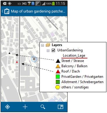
Then, also in ArcMap, the attribute is chosen which the depiction of the points will be based on. In this example, the attribute Location_Lage was chosen.
In addition, according symbols are assigned to the specific values (see screenshot). This is done under Layer Properties > Symbology.
The designation of single attribute symbols could also be carried out in ArcGIS Online. However, currently, only a reduced choice of symbols is available online.
Save your ArcMap document as 'UrbanGardening.mxd'.

Additional data processing steps are not necessary for this example.
3. Creating a Service
In the next step, a feature service for ArcGIS Online is constructed within ArcMap. The generated feature layer should be incorporated into a map and made publicly available. In order to carry out the following steps your require an ArcGIS Online licence. If you do not possess a licence you can download a 60-day trail version here:
external page ArcGIS Online trial version
You can find detailed instructions for the next steps here:
Download Instructions: Creating a Service for "urban gardening" (PDF, 596 KB)
4. Using the Collector App
If you have carried out steps 2 and 3 your map is now available. Open the Collector for ArcGIS app and choose Add new ArcGIS account under Switch Account. Enter the address of your ArcGIS online subscription and click on Continue, then, enter your username and password. Under All Maps your application appears.